Tapa Tope Kalān
Plan of Tapa Tope Kalān drawn by Pr. Z. Tarzi (Tarzi, 1997).
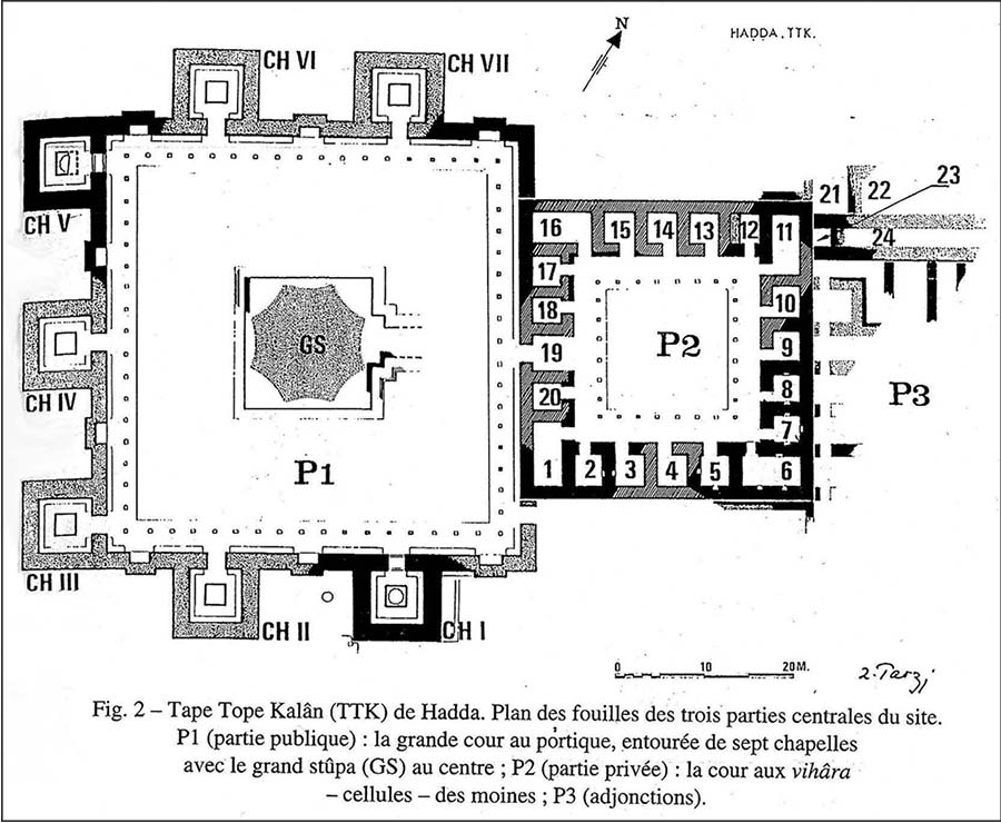
Excavated by Zémaryalaï Tarzi, the site of Tapa Tope Kalān (abbreviated TTK), characterised by a very large Great Stūpa (GS), is located approximately 200 metres north-east of the modern town. It had been identified by Masson, who called it "Tope Kalān," and then identified by Barthoux as "Borj-i Kafarihā." Three distinct complexes could be distinguished on the site. The Great Stūpa stood at the centre of a courtyard (P1) delimited by seven roughly square constructions, each containing a stūpa, linked together by an enclosure wall.
To the north-east, adjoining and communicating with the Stūpa Court, lay the saṃghārāma, Vihāra P2. On the same alignment, adjoining to the north-east, a third complex P3 had been uncovered, built on three sides of a courtyard. Unfortunately, the badly damaged south-east sector had not been preserved. Vihāra P2, along with the Stūpa Court P1 and the Great Stūpa GS, date from TTK I. During TTK II, embellishment works were undertaken in Vihāra P2, on the Great Stūpa, and the complex of cells and corridors (P3) was constructed. Finally, the stūpa of chapels CH I and CH V surrounding the GS are attributed to this period.
Excavations in this sector could not be pursued; however, a testimony from the former Prime Minister of the time, Moussa Shafiq, suggests that there might be a Mahāparinirvāṇa sheltered by construction 22. He indeed remembered playing as a child near a statue housed in a corridor, a statue whose hand was large enough for a child to sit upon.
Explore the objects from this site in the database or on the interactive map.